Reflection

Before this class I never would have actively thought about the process of nature writing, especially in terms of using digital tools. In the past, any nature writing I had done was for class assignments. While this was indeed a class, but this course made me think deeply about it and how we interact with the spaces around us.

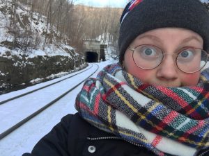
In class we discussed how nature writing can occur in places such as bustling cities. The idea originally blew my mind. I had some difficulty seeing a place such as the Hoosac Tunnel as a place where nature writing can occur. But here I was, stepping forward suggesting it as a possible project of focus. And I wasn’t ready for this space to make the impact that it did.

Before this class, having any of my work visible to the rest of class would make me anxious, but in Storied Landscapes I knew my work would be on full display for not only my classmates, but anyone else who stumbles across it. This course gave me the confidence that I lacked in my writing, and my nature writing, and encouraged my creativity behind it. 

Focusing on the Hoosac Tunnel has been an adventure. At first, I was confused about the course. I didn’t know what to expect or what I would be doing, or if I could even do it. Thinking about designing a website made me nervous because it was not something that I was familiar with.

Getting information on the Hoosac Tunnel proved to be difficult in the beginning. We do not have an archivist on campus so we had to go to the public library. Unfortunately, that means that we were not allowed to search through the material on our own. The process: ask, and hope there is something. So we asked. And we were handed a single book on the Hoosac Tunnel. We thought that maybe this was all that we would have to work with. It was hard to care about the project when there was nothing to work with. And our other option for a location that we could visit, was equally as difficult in regards to the information that was in the vault. It was hard, and it was frustrating.

Frustrated, we went back and asked the reference librarian if there was anything at all in the vault (the archive). This time, we had a different response. We were told there was “too much”– “too much” to pull. Since we were not allowed in the vault to sift through all of the material, we were directed to an online database that holds all of the information. We had a new problem: we suddenly had too much information. What was it that we were supposed to do with all of this information?

Unfortunately, by the time we were directed to the website, and by the time we were finding things we could do, we were excited with all the options we suddenly had before us. But what we didn’t have: was time. With this set back we were not able to do everything that we really hoped we would do for this project. We had so many brilliant, if I do say so myself, ideas that we simply no longer had the time to do. Our time cut sort by snowstorms and rain on the only days the two of us were able to get down to the space.

I thoroughly enjoyed being a part of the Storied Landscapes class this semester and can proudly say that through this class and some amazing teamwork, Erica and I have been able to create our Hoosac Tunnel site regardless of these roadblocks and plan to continue working on it past this semester. I am still very happy with the way the site has turned out by the end of this course and I’m excited to see it grow in the future. Having Professor Cooper and Professor Wiebe as the course leaders has been a blessing. They both were supportive and ready to help anyone in the class. Without Leah’s help I’m not sure I would have been able to even get this blog up and running.

This class has helped me developed skills that I didn’t realize I needed until I learned them and suddenly, so many doors have opened because of the skills I have under my belt. If I weren’t graduating I would have loved to take another COPLAC course.

Contemporary

Erica and I started our exploration with high expectations, or at least I did, when we decided to visit the East Portal. We were there for perhaps fifteen minutes before we drove back to the West Portal. The East Portal did not seem to offer as much as the West Portal at the moment. At some point while standing beside the East Portal I vaguely recall saying, “I hope the beavers are okay,” as if they would be disappointed that we hadn’t visited them in a while.


This visit to the West Portal was different from our first visit but just as exciting. We were careful not to slip in the thick mud and slush in the area as we made our way back to the beavers. I’m not sure what it was about this visit but the water seemed still, serene… I could have stood there for hours just taking in the scene. Regrettably: I did not take a picture to remember the moment. I did however take a picture of the tree we came across last time. We were amazed to see the progress the beavers had made in the last month. I wonder what it will look like next month.


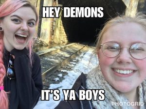
We took a couple time lapse videos to see what the result would look like and moved on to the tunnel. Carefully, we weaved our way around the mud and pointed out all the things we missed when there was more snow: the clear stream to our right, the depth of the stream to the left of the tracks, and all the rocks I naturally tripped over every few feet. And this time when we neared the West Portal: “Hey demons!” To be completely honest I have been completely absorbed with all things… spooky… lately and this time I was ready for something to scare me. This trip wasn’t made for that purpose but I was ready. I lost count of how many times I said, “What was that? What that the demons?” “I think it was a bird–” Erica (the logical one). Ghosts or spirits would have been the proper name but I was lost in the world of memes that particular morning and kept reciting them throughout the trip (sorry Erica).

We spent time taking video of the location, trying out the time lapse feature, testing the slo-mo feature, and taking a couple boomerangs. I thoroughly enjoyed using Erica’s tri-pod and temporarily hi-jacked it (sorry again, Erica) while taking a stroll around the area, still stumbling over those rocks. I was testing out all of these features hoping to make a Hoosac Tunnel “moodboard gif” of sorts, but completely failed to figure out how to upload them onto this blog. As someone who encounters countless moodboards every day I thought it would be interesting to try and make one. While they lack any clear “mood” or color scheme it was fun to make.


To be completely honest I turned the flash on for this photograph hoping to have an experience where I can shout, “There’s an orb!” But all I said, rather dully, “Huh. You can see a couple feet farther if you turn the flash on. That’s cool,” to myself.

One time lapse video I took was in one of the two moodboards that I (dare I say) cleverly titled “Demons”, has (what I believe to be) a funny backstory. I was making a time lapse video of drops of water falling in the tunnel, fascinated with the way the light was shining into the water. I was standing there for only a few seconds when I heard a crack and the sound of water splashing and immediately panicked. “Was that you,” Erica asked me. I remember yelling and saying something along the lines of, “IT WAS A DEMON,” as I ran… It was actually an icicle… And I didn’t stop recording when I started running so the whole thing was captured and condensed into two seconds.

I’m going to try and find a way to upload these subpar moodboard knock-off gifs and if nothing works I will find a new method to display the meme-filled exploration Erica and I experienced on our second visit to the West Portal.


….I wonder what the beavers think of these snowstorms every weekend….

The Plan.

I’ve finally visited Hoosac Tunnel and I’m itching to go back. Standing before the tunnel, imagining what it was like when the work for the tunnel first began… Imagining the conversation that needed to be had when the initial plan failed… Imagining how many people were just trying to do their job but ended up never making it home at the end of the day… Are they still here? In the tunnel?

There are so many stories within and around the Hoosac Tunnel, waiting to be told. It doesn’t seem fair to present them in a singular way when there are numerous tools to help. To simply layout the land with words alone wouldn’t do it justice. The tunnel calls for layers– photographs, story maps, video, audio, and timelines to accompany the words.

We’re lucky to have rich material to work with. With the help of the North Adams Public Library and the North Adams Historical Society, we have extensive information on the tunnel at our fingertips. The library not only has extensive information on Hoosac Tunnel but they also have physical artifacts tucked away somewhere in The Vault. With our differing busy schedules and limited, and sometimes inconvenient, hours at the library it’s a bonus that most of this material has been cataloged online for easy access.


Though are dates are not entirely solidified we have made a schedule of our upcoming goals-to-meet as we start organizing our material and starting up our blog:

    • February 22nd– Compile list of names of those who have died in the tunnel
    • February 22nd- 25th– Pulling relevant material
    • Sometime during the week of February 26th–  Visit the library to see the artifacts
    • March 3rd- Visit to Historical Society between the hours of 10am-4pm
    • March 4th– Visit East Portal; nature writing on site, documentation of the area


We plan on sharing the experience of maintaining the blog and writing pieces to post as well as researching and visiting the site together. But we have also designated other responsibilities between the two of us as this project progresses:

Erica: Filming and editing videos.

*Driver / navigator extraordinaire.

Cassie: TimeLineJS, StoryMap.

*Positive affirmation guide / spotter of beavers.


I’ve always described North Adams as “falling apart” and I’ve heard others doing the same. But what if there was another way of seeing it? What if it was just nature reclaiming abandoned man-made structures that we’ve given up on? What if nature was having a comeback in the Berkshires? Maybe we can start to live with nature instead of destroying nature. Maybe instead of moving on to destroy more land to replace something that has fallen apart… we can try to fix it first…

…like the beavers.

Hoosac Tunnel Visit

This is our first time visiting Hoosac Tunnel. We thought we knew where we were going but we were definitely not in the right location when we first set off. Second time trying to find the dirt path, completely covered by snow, was much more successful. We parked the car in a plowed spot and started our adventure. To our right: a small building. We made a note to visit it on the way back to the car. Our main focus was to just get to the tunnel.

Stumbling along up towards the tracks, We were excited to see them stretch out to our left and our right. We go right, wondering if this was the direction we needed to head towards to get to the Hoosac Tunnel. The crisp snow crunched under boots. I run forward arms out on both side, the contents of my backpack jumping around as I stumbled forward trying, and failing, to keep my balance. I’m sure I looked like a little kid running home from the bus stop as I tripped through the snow, nearly falling several times. We didn’t actually cross the tracks but we did note a small stream on the other side and not long after we noticed another possible stream on our side of the tracks (after almost stepping directly into it).

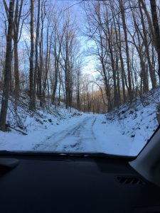
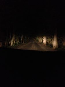
Walking up to the tunnel, the West Portal to be exact, was not as “creepy” as I had expected. Looking back on the moment I feel like that may have been because of the snow that covered everything in the area. It’s hard to understand just how large the tunnel is until you’re standing at the entrance. It becomes even clearer when you see someone else standing at the entrance (especially someone as tall as Erica). The tunnel was decorated in graffiti and a common tag found locally: “you’re going to be ok” was just on the outside of the tunnel. The inside of the tunnel looked unwelcoming. The snow itself didn’t dare to venture inside the endless darkness. The entire area seemed abandoned and silent.

Unexpectedly, we found that the closer we got to the tunnel, the warmer it got. I have had friends describe the tunnel to me beforehand and everyone always describes the tunnel as freezing, especially in the winter. The air seemed to stand still beside the tunnel. Maybe it was the history of deaths in the “Bloody Pit” (as the tunnel is sometimes referred to) that added to the eerie feeling while standing just outside. But the longer I stood there, the more I was able to dismiss that uneasy feeling and enjoy exploring the outside of the tunnel, making excited remarks about the most unexciting things: the track wasn’t directly in the middle of the tunnel but closer to the side, closer to the small stream. Why?

We decided to backtrack before stopping by the building near the car. There was a brick building falling apart just above the tracks. Was this where they originally tried to bore into the mountain? There was a hole filled with dirt. It looked like there were tracks on the ground, but maybe not. The corner of the roof was missing (More excited remarks about unexciting things: “Wow! The corner is missing!”) I have no idea what this place was actually used for. Maybe it was built over the original site and then was used for other purposes later on? I’m really unsure of what to think about it as of right now.

Between the two unknown buildings: beavers. I have never felt so excited about beavers before in my life. We didn’t actually see a beaver, but after identifying a tree that was clearly gnawed on, we ran back and realized we had walked right past a dam without noticing it was even there. I don’t know what it was about that particular experience that made it so exciting when we didn’t even see a beaver. I had seen a beaver walking down my street once before and didn’t think anything of it. But here I was, jumping like I was having the time of my life (I was), pointing at the dam repeatedly.

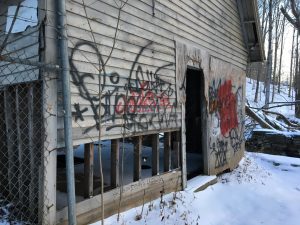
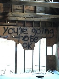
We took a look into this smaller structure, and the first thing we see: “you’re going to be ok” again. This area feels secluded from the rest of town, but the tag reminds us of where we are, that even though we aren’t surrounded by people, people have been here and people will be here (just as we were). Despite the graffiti in the three locations in this area, there were no piles of litter that we could see, and the area did not look like it had been utterly destroyed by people visiting. I hope the snow melts by the time we visit the tunnel again so we can take a closer look at the area.


I hope the beavers are having a good winter.

Natural Bridge


Most of the archival documents that were located were from the North Adams Public Library but were all newspaper clippings or pamphlets of the location (some with varying differences in information on the Natural Bridge). I have been in contact with a professor on the MCLA campus in hopes that he has some more information on the Natural Bridge. While I am currently waiting to hear back from the Environmental Studies professor, I did get to look through said newspaper articles and do some online research. Most the research that turned up online was not particularly backed by any confirmed sources but a general knowledge. I am currently looking for the exact words that Nathaniel Hawthorne wrote about Natural Bridge. A local historian seems to have some useful information regarding this, however with previous experience looking into his work, I am unsure how much of it was accurate so I decided against using his work until I can meet with the professor. I am excited to update the timeline after meeting with him seeing as I do enjoy this particular template (I have used it several times for history and research classes).

The materials that I was able to come across at the public library have increased my interest in the location and have motivated me to continue reaching out to others for resources. Currently the state park is closed so there are no tours. The park opens late in May so as of right now I am trying to reach out and see if it is possible to still schedule a tour, and if it is not, if someone is willing to answer a couple questions over the phone about Natural Bridge since the state site provides little detail on the location.

As I already said, I have used this particular template/program before and after familiarizing myself with it once more I can say that I still enjoy it. It helps organize thoughts and keeps the dates in order so you don’t have to flip back and forth trying to manually organize everything on your own. I think that for this project it is incredibly beneficial to utilize this program. I think that StoryMap (which I have never had the opportunity to use) would be beneficial for Natural Bridge if we had photographs of the arch, the dam, the gorge, the open space, the sculptures… I think that once we make the trip over and take photographs it will be interesting to see how it looks using StoryMap. We are planning to head over soon to see if the sound installation is still being used/ if it is still running despite the state park being closed.

I’m excited to gather more information and personal photographs on Natural Bridge in the next few days.


Locations

Trying to find locations was more difficult than I had originally thought it to be. When meeting with the local reference librarian, we had to have locations already in mind in hopes that there would be something in the archives (referred to as the “vault”) on those locations. Most sites we found were located in a pamphlet for the Natural Bridge State Park, which was the one site that the reference librarian was certain there would be information on in the vault. Some locations that we found after taking a look at the tourist pamphlet were: the Hoosic River and the Hoosac Tunnel.

Hoosic River (Hoosic having many different spellings from the Algonquin name originally given to it) was not something that we focused on at the time of our meeting but does have several possibilities to explore for this project. The Hoosic River Revival in North Adams wishes to re-establish the river into our community after having fifteen foot high walls built around it as a way of flood prevention. While I am almost certain that there have been no recent developments regarding the revitalization project for the Hoosic River it would be interesting to get accounts from those who started this project about the river and learn about what the river once offered the community compared to the situation it is currently in by being hidden behind these man-made barriers. However, we could hit a lot of roadblocks with Hoosic River as there seems to be little information beyond environmental writings.

The Hoosac Tunnel is a well known railroad tunnel with an immense amount of history attached to it. With this location we have the possibility to discuss not only the land that it passes through but the railroad industry, local history, and the technology and machinery that was used to bore through to create the tunnel. Without having deeper research to look into as of right now, it’s difficult to see just how much we can delve into but regarding the immense amount of history behind this location I imagine there being plenty in the archives. 

One of the first locations that came to mind for this project was Mount Greylock. This location is promising when considering the proximity to campus, as well as the recent discussions and attitudes towards the location because of its mention by J.K. Rowling. This area provides several different activities for visitors from hiking, to camping, to hunting, and to snowmobiling. Despite being such a well-known location that is associated with our area, it does not seem like there would be a lot to discuss or look at with Mount Greylock as our focus.

Natural Bridge State Park was the one location that we were able to find some information on from the vault with the help of the reference librarian. Though most of the information we were given were newspaper clippings of advertisements or information about a change in hours, this location has a lot of possibility as a focus for this project. This piece of land has a sixty foot gorge as a result from glacial erosion as well as a natural white marble arch. Another bonus is the piece of literature that Nathaniel Hawthorne wrote about the location back in 1838. It would be interesting to compile what Hawthorne wrote about Natural Bridge, as well as other visitors’ experiences, along with our own to track how this location has, or has not, changed in regards to not only the landscape but also what the location means to community members.

I feel that the best locations for this project would be the Natural Bridge State Park and the Hoosac Tunnel. With both locations we can delve into other aspects along environmental factors both past and present.

Great Pond, Belgrade

Great Pond, Belgrade

I grew up spending my summers at my grandparent’s “summer home” in Belgrade, Maine. Foster’s Point to be exact. One moment you’re on a paved main road driving through Belgrade and the next you’ve turned right and up a dirt path, straight into the woods. But what I remember from when I was little is different from what I’ve noticed my last two summers there.

The dirt road at night, 2016

We’d slowly make our way down the thin one lane dirt road to the house, making comments about the drop off on either side, lined with dense trees. If you were to look up expecting to be greeted by a clear blue sky, you’d be disappointed. The sky was barely visible but you could see rays of light shining through the vibrant green leaves. The road had an entirely different feel at night, and for a seven year old it was absolutely terrifying. It gave the feeling of being trapped by the trees, of being surrounded by only darkness. Driving down the road thirteen years later after leaving a horror movie with your family was a different kind of terrifying that resulted in lots of yelling, jumping, and fights over what kind of animal just skittered in front of the car. The road is one of the only things that has remained constant.

In the summer there was always just the slightest breeze to keep you comfortable until the rain that was sure to follow in the evening. I learned early on that taking walks down the dirt road were better in the early morning than in the late evening if you didn’t want to constantly swat insects away from your face. I wish that I had appreciated those walks when I was younger. The walk to the point was always interesting, but only when I look back on it now. There were rocks to kick, lichen to admire, blueberries to pick, houses on the right, endless trees to the left. Veering off the path to walk through the trees was different because there was no path. No one walked through the trees on the left. There were ticks, ditches to fall into, unseen roots waiting to be tripped over, fallen trees waiting to be climbed over, and hidden blueberry bushes scattered throughout the woods.

From what I remember, the point used to be accessible.

My grandparent’s dock, taken from the second dock, 2017

There wasn’t a real difference from walking out the back door of the house and down to the water, except for the view. And if the water was low enough you could see a line of rocks leading straight to Blueberry Island. But there’s a house there now. Last time I took a walk to the point a car was parked there. And the walk to and back from the point isn’t so spectacular anymore. The trees are gone. They’ve cleared out most of the forest. My cousin accidentally ran through the clearing (not knowing it was private property) and he said it’s much larger than I imagined it to be. I’m not sure what it’s for but some people assume more houses, others are thinking some sort of parking lot or a paved road. The walk to the point, now a parking spot, is now lined with houses and water on the right, and an empty area once occupied by an abundance of trees, broken branches from heavy snowfall, soft ground to sink into, and plants I still don’t know the name of, and some plastic bags and bottles tucked away behind fallen trees and rocks next to the road. I don’t ever recall seeing this much plastic when I was little. But then again, when I was really little I thought that the fuel sitting on the water was “pretty” because of the rainbow it would make.

Blueberry Island, taken from the boat, 2017

Blueberry Island. The bushes were so full that you could touch a blueberry bush and the small wild Maine blueberries would fall straight into your metal pail. We always made sure to leave enough on the bushes for next year. But I suppose we weren’t the only people who had tied our canoes to the trees and climbed over the steep edge of the tiny island for a snack later. This past year, I didn’t pick any blueberries because I couldn’t find any. And the few that I did find, I left on the bush in hopes that maybe next year there would be more and that the blueberries could find a home on the island again. I lost hope for Blueberry Hill. My family didn’t even bother going to visit after we heard that it was over picked. Nothing left. Bare blueberry bushes.

Until the last three summers when I started going back to the house on Foster’s Point, I wondered what happened in all the years that I was away. But now I know. The land was used. Not properly cared for– just used. But I wonder, has it always been like this?


Me, in front of the boathouse that is no longer there