There is a place, near SUNY Genseo, called Fall Brook, that’s hidden in the woods on the side of the road. The best way to get there is to drive south of Geneseo, pull into the driveway of an alfalfa dehydrating plant, pull back onto the road (but now in the opposite direction), and then park next to the guard rail. Sometimes you’ll see another car there. More often than not that other car will have a sticker on their back window of two crossed rock hammers. It’s the unofficial (but official) symbol of a geologist. My car doesn’t have that. My car should probably have that on it.
There’s a small hill I have to climb down, though thankfully the vegetation isn’t oo thick due to the August heat, until I find a chest-high fence. There’s a break in the fence, then enough to slide through with an empty backpack on. It feels sketchy, but this land is owned by the school or something like that. I’m definitely allowed to be there.
There’s a path faint enough to follow if you already know the way. It goes through a field and then some tall trees. They may be maple or oak, but I’ve never been good at plant identification. Beyond the trees there’s a stream, which is low given the month. I’ve been here in the spring, after the snow has melted, and the stream is too full and too fast to easily cross. At this point, I prefer to go upstream, there’s more to do upstream, but if I followed it down I’d find rocks from an art installation I did the semester prior.
Participants wrote things that they wished could erode/dissolve away on a rock, and then I promised to put those rocks back into the environment and allow nature to do its work to erode the rocks and the thoughts with them. I looked around I might find fragments of a thought, written in silver sharpie, lying face up in the stream, where my friend Evan and I had chucked them.
(Question: is sharpie ink environmentally friendly?
Answer: I still don’t know, but technically they are “nontoxic” markers.)
This time, though, I go upstream. The street is still audible, but the gorge starts to swallow with tall walls of black shales. Sometimes I’ll wanted over to the shales, snap them, and hold the clean break up to my nose to smell the gas in them. I have a geologist friend who wanted to set one of these shales, often called oil or anoxic shales, on fire when he first learned about them. I asked him recently if he still wants to try that. He does.
The walk upstream takes maybe twenty minutes. Leaves dapple afternoon sunlight, and occasionally I’ll stop to look for fossils. Most of the time I don’t see any, because the oil shale around here doesn’t typically have fossils in it. The majority of fossils are in the rock layer below the oil shale, which the river cuts into further upstream. I can spot the change in rock type, from black shale to a light grey shale. Around a bend, the fossil bed emerges at ankle height.
My hands scan the rocks for the bumps of trilobite exoskeletons and the disc of Cnidarian stems, trying to piece together that ancient ecosystem. I pictured the trilobites, almost beetle-like, crawling across the muddy sea floor through a field of Cnidarians that swayed like sea-lilies in the gentle waves. I see rugose corals, 2 inches long and shaped like horns, which would have faced, large end up, toward the surface. I see a branching, delicate graptolite that might have lived among the other animals, as I pull another rock out of the layer, hovering just above the water level. I try to imagine myself standing on the ancient ocean floor, but the image I had of the sea life breaks apart as I picture my red, polka-dotted, rain boots in the mix.
Eventually, I pack away my collected fossils and continue the last 10 minutes to the end of the gorge. The sides of stream get taller, steeper, and tower over me as I walk. Occasionally, bits of shale will tumble down these walls and send a chime echoing through the valley. I go from walking on the stream bed pebbles to climbing over boulders, trying not to get my foot caught in the gaps. Sometimes I’ll notice a red or pink gneiss, a metamorphic rock, that sticks out from the grey, sedimentary rocks of the stream. We don’t organically get those kind of rocks in Western New York, but glaciers brought them here from (most likely) Canadian mountains, and I’ll pick them up to bring home. My best friend teases me about it. He calls my rocks tchotchkes when I display them in my room.
Beyond these boulders is what most people come to Fall Brook to see: The waterfall. It’s very tall, perhaps 2 or 3 stories high. There’s a plunge pool beneath it where I could swim, if I remember to bring a bathing suit (I never remember to bring a bathing suit). Behind the waterfall is a ledge of dark shale, cut out by the water hitting it over time. I sat there with my friend, looking through the waterfall at the boulders, the trees, watching the sun cast it’s angled light into the valley. I draw my knees up to my chest, enjoying the spray coming off the falling water.
I choose to write about Fall Brook Gorge as my introduction, because of its hiddenness. It’s very much a place that you’d want to call “nature,” over, say, calling your own home “nature.” It’s hidden away through the trees, and the waterfall is hidden even more so by the bends in the stream. Not everyone who knows about Fall Brook knows about the fossils, so those are almost hidden from common knowledge (though, any geologist would be happy to show them to strangers, as I did when I visited the spot last August). The fossil bed, itself, can even be hidden if the water level in the stream is high enough. The rocks from my project aren’t known to be there (aside from the handful of people I told about it), and, they’re located in the opposite direction from the path most people follow.
Why hiddenness, though? What about that interests me? I like the hiddenness of a space, because it allows for curiosity (what more do I not know? A: who actually owns the land, how SUNY Geneseo has permission to use it, the human history of the land) and the childlike pride that comes with knowing a secret about a place.
Some of these “secrets” I only know, because I know the language of geology and can contextualize what I see using that language. Macfarlane, in his article “Generation Anthropocene: How humans have altered the planet forever” discusses the importance of language in how it alters perceptions, even starting out the article with the definition and history of the word “solastalgia.” For me, Fall Brook is a special place, because of how I can read the land. I can identify the shale & be able to imagine the deep water, muddy environment that created the shale. I can picture the animals that are now fossils and how they lived in that environment. I can fast forward in my mind and picture how the glaciers that went through the Geneseo valley might have looked like. In a way, being a geologist is like have instant access to a million-year-old (& often incomplete) flipbook in your head, seeing how the land has grown and changed.
To relate this back to Macfarlane’s argument on the importance of language, I want to suggest that it’s not only language but its context that shapes our perception. See, knowing the word shale and being able to identify it doesn’t change how I see my environment. What changes my perception is the context around the shale, knowing what creates it, how it can vary, and so on. So, while I think that it’s important to have the words for Anthropocene, I think it’s even more important for individuals to identify with them and experience what they mean.
This conversation relates to another one we had in class of “how do you convince someone who doesn’t believe in climate change. I talked in class that getting someone to understand climate change and the difference between the local and the global world is the best way to change their opinion. Given my stasis as a science major, I understand why that statement was taken as the “if we present people with facts, they’ll change their opinion” argument. I wasn’t trying to say that, though, I think, since I know (through scientific studies) that giving people factual information will often just make them more steadfast in their uniformed/ factually incorrect beliefs. Instead, I meant that if you get someone to understand, not the definition of a word, but its experience, you can open up a road to changing their opinion.
I mean, why do people read fiction? It’s not to learn anything specifically. It’s not to be presented with facts or definitions. It’s to experience someone else’s life/story. It’s driven by curiosity in how other people think and live. In that way, reading (or even watching) fiction is a practice in empathy, in finding meaning out of story. It’s through that sort of empathy that opinions change, and why writers need to team up with scientists to tackle issues of climate change, mass extinction, and other “hyperobjects” as MacFarlance phrases it.
My vignette of Fall Brook Gorge was meant to help the reader move through that space and see what I see. It’s secondary function, though, was for the reader to empathize with a scientist (classically hard people to empathize with, I know) and feel the humanness and imagination that comes with scientific knowledge, imagining crawling trilobites, collecting rocks like a kid, and wanting to go swimming under a waterfall. I think, as we continue through this course, my goal as a writer/researcher/scientist is to openly operate in the grey areas between disciplines, because I think that’s the only way to get people to care about the environment, allowing them to feel empathy for facts by coating them in a narrative.
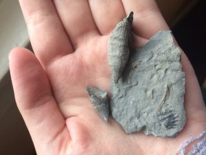
(Horn coral fossils and the bottom half of a trilobite.)