Reflection

Through the Storied Landscapes course, I learned a lot more than I thought I would. At the beginning of the course, I was hesitant. I did not know what I would get from the course, either as a grade or for what I would learn. I also was not sure what the final project would be, what it would look like, and overall I was really unsure with everything that would come from the course.

In the beginning, I felt a bit confused and lost. This was definitely a fault of my own, as I didn’t take the time to ask questions or ask for clarification. I felt like everyone knew what was happening in the course and I was the only one that did not know what the course was really about. I feel like this was partly due to the fact that our campus doesn’t have a COPLAC trained person on site, so I felt like I was constantly scrambling to figure things out when others already had.

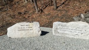
Part of the problem was trying to explain what exactly COPLAC is, and then trying to explain what the class is about, what exactly we needed as far as archive materials and information. It was really hard to get the information out of the reference librarians, they didn’t realize we wanted everything about the Hoosac Tunnel, and it took us quite a few tries to get all the information we could. It wasn’t like they were withholding information, it was like there was just too much and they just didn’t want to go find it all. It was really difficult to find information or get interested in the project itself when you’re not given all the information for a project until a few weeks before the project is due.

Once we were actually given all the information about the Hoosac Tunnel, it felt like a scramble to get everything together. We definitely did not have enough time to get all we wanted done, and we definitely did not do everything we said we were going to do to the website. One of the main issues with the website is the severe lack of video.

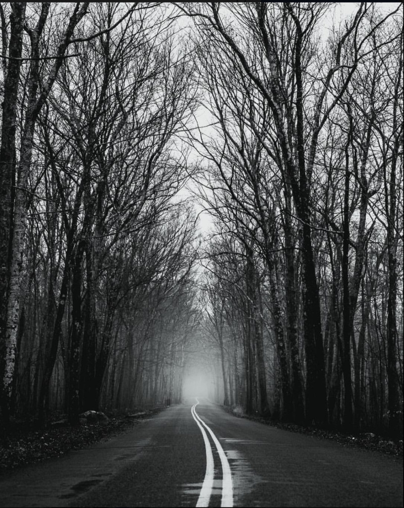
We really wanted to create an immersive experience with videos for each page. These videos would take visitors on something like a tour of each location, and in doing so would help visitors feel more for the location, taking them into the nature and not just the history of the location.

This idea fell flat for multiple reasons.

Firstly, the weather. We are situated in the Northern Berkshires, which creates quite a lot of snow in the winter. Even when the weather forecasts say it’s not going to snow, it does. The weather forecast will say it’s sunny and it’s not snowing, but you look outside to see snowflakes and two inches of snow on the ground! The consistency of the abnormal weather patterns made it difficult to go out and go to the locations.

Another problem we had was space on my computer, and other technological issues. My computer simply did not have enough memory to handle all the videos we had (only two videos we had made) and it was incredibly difficult to try to edit and upload videos while my computer kept getting hotter and hotter, and yelling at me that there was simply no more space on it for more files.

The third problem was time. We simply did not have enough time to create all we wanted to create. I wanted to get more and more information before we actually sat down and recorded something, as I wanted all the information to be correct, have ample sources, and be interesting for the viewer with ample shots of the location. By the time we got all of our information and the weather finally settled down, there was simply no time to do everything I wanted to do. If we had more information from the beginning, maybe I would have been able to accomplish everything I wanted, but maybe not.

If I had been able to do this project again, I think I would have been more aggressive in asking for and finding information. From the beginning it felt like we did not have any information at all, which was really disheartening. By the end, it felt like we had way too much information and no time to add it all.

I also would have bought an external hard drive or something so that I would be able to have more videos added to the site without fear of running out of memory on my computer. That alone was really frustrating and I don’t want to have to do that again. If I do a project like this again I’ll be sure to have some kind of secondary memory source so that I can do all I want to do.

Overall I am really happy with how the website came out. There is so much information that we have discovered through this project, and especially in learning about North Adams, it was really rewarding doing this project. Cassie and I have even discussed continuing with research of this project, and continuing to add to the website because of how interested we are in the topic. We have really started to understand why some people have become obsessed with the Hoosac Tunnel, because there is so much history and so many secrets to discover.

I am really happy I was able to participate in this course because it really allowed me to flesh out skills I already had and add more that I never thought I would have. I’m really happy with how the project came out and I’m really happy that I want to keep looking into the tunnel’s history.


East Vs West

The two sides of the tunnel offer completely different atmospheres. On one side, the mark of humans, as if in a post-apocalyptic world. The other, the bruise of human interaction at every turn.

The West Portal is marked by age. Every part of the area is weathered and worn. A muddy, dirt path, covered by snow on all sides, leads from the road. It is barely wide enough for a car, with tracks in the mud too wide and deep for a low car to pass safely through.

A yellow gate that is never closed marks the entrance. Like other parts of the tunnel, it is rusty, covered in vines and clearly in need of repair. The websites that talk endlessly about the tunnels all agree that the gate is often closed, or the area is often patrolled by police, or plastered with “No Trespassing” signs. As luck would have it, we experienced the opposite. Empty, open, and despite the recent snowfall, quite warm weather as well.

The path continues on towards the tunnel, past the parking area, past the Old Building that contains the only signs of “No Trespassing,” although merely for safety. The path can lead three ways, towards the Old Building, another way towards the beavers and the old kiln, and the last, which leads directly to the gaping mouth of the tunnel.

The warm weather is making the snow melt, though the closer to the tunnel, the colder it becomes. Icicles hang from the ceiling of tunnel like teeth, dripping water into the streams on either side.

A soft trickling sound can be heard, water coming from between the bricks in the wall, releasing into a pool full of grime and leaves.

An imagery of a mouth comes to mind, saliva spilling into the gaping hole of the mountain giant, razor sharp crystal teeth, and train tracks as the tongue. The only thing that saves me from the thought is the ever present Berkshires tag, You’re Gonna Be OK, written just on the edge of the tunnel.

Visiting the West Portal a second time, the area has changed. The beavers are still here, chewing slowly away at a pine tree at the edge of the dammed off stream. The progress they have made allows me to more easily see the changes that nature has made in reclaiming the space.

The progress nature has made is more easily seen while contrasting the West from the East.

The East Portal is miles apart in both location and by atmosphere. The drive is around 20 minutes long, over the Berkshire Hills, past the summit and the hairpin turn, and down into the depths of a valley 4.5 miles from the West Portal.

This place has the imprint of humans every 30 yards or so. Houses spotted on the drive down, cars and jungle-gyms, the stark absence of snow. Already the differences are so drastic. We ooh and aah at them, the tiny cabins with the view of the lake. Cassie remarks to me where she would place a lawn chair by the lake, and we hmm at the idea of the area flooding come spring and heavy rains.

The rest of the trip is strangely marked by the sign of other humans. A drastic change from the previous, where there was no one, hardly any sign of recent human activity.

Here, we parked to the right, where there was significant space for cars, whereas at the West Portal there was barely room for two, maybe three cars.

There was a car leaving when we arrived, two women who drove up in a large navy blue truck, embellished with pink, Harley Davidson stripes along the sides. They didn’t offer hellos, or any other indication to why they were here, only leaving as quietly as we arrived.

We cross a road to start on the short walk to the tunnel. Here it’s a shorter walk, and we feel as though we’re being watched. A car with Connecticut license plates sits on the other side of the tracks, it looks like a cop car. We keep to the left of the tracks and only cross over once to look at a memorial.

Our journey ends there when we see a sign that reads, “DANGER, ACTIVE RAIL LINE, NO TRESPASSING.” We decide that it’s a better idea to take pictures from afar, and not risk it. The active rail line, the strange car, and the waterfall nearby keep us firmly planted in one spot.

This side is more human than the other. The area seems more active with human activity, with the houses, the frequent visitors, and especially from the maintenance truck that drove up just as we were heading out. Despite the portals connecting to the same tunnel, the differences are startling.

On one end, it seems to be an aspect of life. The East Portal, alight with activity, with continued use and maintenance.

The tunnel itself, although grim, seems like the death of the area (remembering, also, how the fumes inside the tunnel will kill anything that is in the tunnel while a train goes by). Because the tunnel itself killed so many in production, this only reminds us of the ghost stories, the afterlife that the tunnel brings.

The West Portal, into the conclusion, appears as the regrowth. The moment where humans have gone and the beavers return, buildings fall apart and few come to see what has become of it.

Strangely, or maybe not, we find the West Portal far more comfortable. Perhaps it’s being closer to nature, or the excitement of the beavers. At the East Portal, we spend ten minutes there, tops, and leave practically right away. The adventure wears off quickly, and we pack up to travel to the place we know and love: the West.

Contract Narrative

North Adams exists as a hub of activity, and commonly is called a “drive-through town.” Even the trains are driving from one place to another, trying to get to somewhere else, never stopping for long.

Much of North Adams is historic, run down, falling apart or somehow being “reclaimed by nature” if you prefer to romanticise it in that way. Old Victorians, falling apart, or apartment buildings marked with signs that say it is no longer safe to enter. One can walk into any old house and see dandelions peeking through the floorboards.  Or walk through the various historic sites, of the Hoosac Tunnel, perhaps, and see pieces of the past, where nature exists within history.

Like the beavers who live alongside the West Portal, creating shapes, changing the landscape, and adding to it as parts break, we as humans do the same thing.

The history of the Hoosac Tunnel is rich with individual narratives, horrible deaths, and more, which enable the stories of the tunnel to be all the more interesting. With the wide range of stories, there enables a wide range of materials to show them, including TimelineJS, Storymap, of course visual aspects such as video, and the more straightforward nature writing.

The Vault will play into our writings as well. The archives we have access to, mostly documents which have been scanned and posted online, will aid us in our research. Physical artifacts will help us as well, and the aid of the local historical society will be of great use to us.

Our schedule is very loose, as we may change dates as time goes on, including adding more due dates as they come.  For now the schedule is as follows:

February 22 : Compiling a list of names of dead

February 22 – 25:  Figuring out what materials we need

February 26 – March 2 : Visiting the Library and the Vault. Seeing the artifacts

March 3 : Visiting the Historical Society (10am to 4pm)

March 4: Visit the East Portal, nature writing on site, some B-roll footage if possible.

We have also designated some responsibilities for the two of us.

Cassie: TimeLineJS, StoryMap, maintaining the blog/ writing pieces, research/ visiting the site. Positive affirmation guide / spotter of beavers.

Erica:  filming and editing videos, maintaining the blog/ writing pieces, research/ visiting the site. Driver / navigator extraordinaire.

The Hoosac Tunnel, although well known, has much that is no longer understood. In seeking the truths that the tunnel will tell, we may be able to see more than what even the builders themselves fully intended to show.

A Place Like Home | Natural Bridge

https://www.youtube.com/watch?v=ndgjusplOFw&feature=youtu.be

(Video is for atmospheric sounds and me speaking what is below. You can either watch video or just read below! Same thing!)

Cassie and I walk through about three inches of snow and ice, up a windy hill to the state park both of us have been to before. The last time I was here, it was summer. Myself and two other friends, packing water, snacks, and towels, wearing bathing suits, preparing to travel into the gorge to go swimming.

It’s February now, a new year. Every inch of every surface is covered in a fine layer of powder.  Footfall amplified a thousand times by the tiny crystals of crunchy ice. An inch of snow today, and twelve inches tomorrow. We bundle up: hats, three layers of jackets, two pairs of socks, pants, scarves. We make sure to bring gloves. It’s below freezing, you can feel your skin drying, hardening, when it’s exposed too long.

Two dogs greet us before we get to the top. The second becomes our guide, weaving in and out of our legs, bringing us to the place we wanted to go, the stairs that lead up to the bridge.

The stairs get steeper as the sound of rushing water gets louder. Inside the gorge the water carves paths in the stone, eroding the walls, changing the course of the water.

The stairs connect with every part of the gorge and surrounding area. The land is manipulated by human hands. Like the water, the land is changed with it. A dam, cutting the river in half, ice piling up like sugar amidst the snow, ice, slush. An abandoned mill, the foundations still standing, signs proclaiming the land is not longer safe. To the bridge: the stairs and pathways floating above the stone, fences cutting the picturesque landscape into pieces.

The water is endlessly gushing, gushing, gushing.

Away from the bridge, from the dam, the sound fades. Again the sound of our shuffling, crunching footsteps return, the laughter never ceasing. Walking over ice, lamely dancing on the slick pavement.

Human hands have touched everything. A crumpled, half soaked pile of brochures, proclaiming, “It’s your nature” makes me uneasy. The quiet, empty land meant for cars next to a building with a sign out front that says, closed for the season, just reminds me of Cassie sending an email to this state park only to receive one of those “this address does not exist,” automatic replies.

This place feels abandoned in the off season. Empty. The only people coming are those who bring their dogs, unleashed, letting them run free among the old quarry. For some reason I like it better in the winter. Seeing it appear untouched it brings me back.

I remember why I came here, visiting the area for the first time when I was still in high school. Driving over the hairpin turn, overlooking the mountains that aren’t actually mountains and thinking how this is a place that feels like home.

The Hoosac Tunnel

Archival documents were mostly found online through the form of photos and maps. The most promising vessel of information discovered from the North Adams Public Library happened to be Builders of the Hoosac Tunnel by Cliff Schexnayder. This particular text contains over 500 pages of history of the Hoosac Tunnel as well as over 123 pages of bibliography and endnotes (a true brick of information). With some help from a mutual friend (an expert in the Hoosac Tunnel, and currently working as a railway dispatcher near Boston), I was able to find some promising sources of photos, stories, and other information. Some websites need some further research to prove the validity of the information (for example I found some conflicting information from one site to the book – the same event, however dated during two different days), however they do seem promising as far as picture sources.

Overall the materials found and used enabled me to understand much more about the location itself than I knew already. Living in this area for 3 years, there are a lot of stories you hear just in day to day life, especially from asking locals or those who have lived here their whole life. Actually sitting down and being able to read about the history of this place, as well as seeing this place in the few photos taken as well creates a new life for this location. It is really different sort of understanding that there are a lot of ghost stories surrounding the area and then actually discovering that over 100 people died in the tunnel itself (not to mention the some 90 people that died elsewhere around the property).

The TimelineJS program really puts everything into perspective, seeing everything laid out in a numerical way. Watching the creation of the tunnel, essentially, as the timeline lays out the dates. I think it is really useful, especially for this project, because it was a very long process. The other program, StoryMap, would have been great as well, however due to the fact that we do not have pictures of the locations yet, it would make it difficult to create a map. Overall the Timeline seems to be a better resource for us for this location. There are a lot of events happening almost simultaneously, so it is nice to see it laid out in a clean, simplified way.

Once we have more information, videos, other photos, and more, I think it would be interesting to combine the information into the StoryMap as well as use the TimeLine. Because the tunnel is so long (over 4 miles) it would be interesting to layout all the information possible onto a map. For now, however, the timeline works well with what we currently have.


Book Citation:

Schexnayder, Cliff. (2015). Builders of the Hoosac Tunnel. Portsmouth, New Hampshire: Peter E. Randall Publisher.

Glacial Grooves & Haunted Hoosac

A huge problem we had trying to meet with our archivist was actually meeting with an archivist, as well as getting access to information that would help us with the project. We were able to meet with reference librarians at the local public library and look at the information contained in the vault, however archive materials were limited (no surprise there).

There was also some issue with trying to explain exactly what we were doing as an overall project. It was difficult to explain how we would be using the information while we didn’t exactly know what it was we were looking for in the sites. Deciding which sites we wanted to look at was difficult as well, due to the fact that we were not sure what information was available to us. We tried to name a few locations, such as Mt. Greylock (tallest point in Massachusetts), however there was no information on that particular location.

We asked about Natural Bridge State Park, and there happened to be some information in the vault. There was mostly old information such as pamphlets which described the location, the trails around the location, and other small amounts of information. There was a few books but those did not contain much information, only some quick facts in the first ten or so pages, with the last thirty or so pages being completely blank.

Other options for this location include actually going to the location as well, as there are tours offered, so more information can be gathered through other means (not solely by archives).

Another location we thought of, however not until much later, is the Hoosac Tunnel (there are multiple spellings for this location including Hoosic, Hoosack, Hoosick, and probably a dozen more). The location itself is full of much history, lore, and even ghost stories, which adds some mystery to the entire area.

The location itself is a railroad tunnel, and seeing as North Adams is a hub for all things train, this seems like a really good idea to explore the archives. Although we haven’t seen the physical archive materials for this location as of yet, there is some online archives as well as a literal train museum which can no doubt help us.

Other locations we discussed included the following, with some of the reasoning behind it

  • Mt. Greylock – Location of J.K. Rowling’s Ilvermorny School (American School for Wizardry). The tallest point in Massachusetts. A “fun” fact: Mt. Greylock is not actually a mountain, it is about 8 feet short of being considered an actual mountain.
  • Natural Bridge State Park  – Beautiful location with easy access and cool rocks! Access into the gorge possible to see the natural bridges from the bottom. Includes glacial striations (or ‘grooves’) – the tracks from glaciers moving!
  • Harriman Dam, Whitingham, VT – “Morning glory” spill way, reservoir. Very cool looking! Although in VT it is about 40 minutes from us so we decided against this idea pretty quickly.
  • The Bridge of Flowers – man made bridge which is covered in a flower garden. Self explanatory, however does not bloom fully till late spring/summer. (We’re definitely going anyway, even if we’re not writing about it!)
  • Hoosac Tunnel / Railroad – North Adams is big for their railroad so my initial idea was just “railroad.” The Hoosac Tunnel became the focus at that point due to the fact that it is surrounded by so much lore/history/ghost stories/etc. The entire location is very interesting and also nearby, which is good. There will be a lot of information that we can gather about this location as well.

It will be interesting to discover more about the locations we have chosen, the Hoosac Tunnel and the Natural Bridges. Being in this area there is a lot of information that one just picks up simply from day-to-day conversation. It will be interesting to separate rumor and lore from truth that we will discover while conducting research into the areas.

The Road That Meets Salmon River State Forest

A long stretch of road, running into the distance, curving out of sight. Trees as far as the eye can see, stretching miles in every direction. The trees, some like giants stretching up into the sky, curve out and then up, creating a barrier from the outside world.

In the early mornings, fog lazily shifts over the asphalt, moving through the trees like waves. The area is quiet, nearly silent, save the sound of a lone car engine or the sound of waking birds. During the warm evenings, peepers hop over the road, soaking up moisture from the air on their travels to the marshes and streams in the forest.

The road stretches on for about a mile before any houses come into view. The houses, with driveways so long one cannot see them from the road, unless it is winter, when there are no longer leaves on the trees.

When the nights are long and dark, the road takes on a very different atmosphere. The only light in the area is the light of your own headlights, and with how the road curves, nearly impossible to see deer or other wildlife before they run in front of the car.

Photo by Adam Ramsay
IG: adamramsay


Twelve years ago, during the warm summer nights, frogs covered the roads on the drive home. There was no way not to run them over with our car. As the years passed, the number of frogs dwindled. We’re lucky if we see one on the drive, maybe two if we are really lucky, for the entire summer. I never questioned the disappearing frogs till years later. It seemed as though they disappeared in a single year, like a snap of the fingers, they were gone.

Other creatures I had never seen, such as the salmon with which the forest got its name. More creatures I saw less and less: the snakes which ate the voles that dug up our yard, the hawks that ate the snakes. Squirrels. Where did the squirrels go? Even the orioles my mother likes to feed, some years they don’t come by, even when she leaves oranges for them in the bird bath.

The road splits two forests. One on the left, Salmon River State Forest, and the right, a commercial lot that’s been bought, sold and re-sold, so many times it is unclear who owns it anymore, or what they plan on doing with it. Talks of golf courses. Hotels. Mini golf courses. More houses. Another farm or two.

The years pass and there are more cars on the road. It’s rare now that you are the only one on the road. Accidents become more common. More get frustrated when you go the speed limit, passing you on a double yellow line. The town seems, more than ever, to quickly fix the roads when they look worn down. They added a rumble strip to the middle of the road to stop people from passing or maybe just driving in the center of the road (which didn’t work).

Nowadays, it is rare if you don’t see trash on either side of the road. Filled, white, ten gallon plastic trash bags. McDonald’s bags. Empty to-go cups with the top popped off, plastic straw lying two feet away. Lottery tickets in the dozens, thrown out of car window, scattered all over the asphalt.

This place is different, changing. The forest changes as the world changes.

As I got older, the forest became less magical, less mystical than it was before. I learned more about the land, of overfishing which sent the salmon away. Of the drought coming in full force, increasing the number of gypsy moths in the area, changing how the trees look, changing how the summer sounds. This including the history of gypsy moths, the invasive species we failed to eradicate.

Lastly, of the frogs, as they started to disappear, as they continue to disappear. In my freshman year of college I learned about the struggle of the frogs, of species of frogs and bats which are becoming extinct, dying rapidly due to a fungus of some sort, all over the world. As I read about it, it hit me, some ten years after I had seen the frogs last.

From this, the word solastalgia hit me without knowing that the word existed. It was disheartening and tragic, that I had witnessed something that, quite possibly, no one realized what was happening.

The land is changing, moving into something else. Quite possibly ten years from now, there might be a mini golf course or something else across from the place where the road meets the forest.

Or, maybe, as I’ve heard rumors of the salmon returning, maybe something else will happen. Something better, something different. All I know is that the forest has changed because of people. The influence we have placed on this place has changed it. Either through the copious amounts of trash or the disappearing frogs, something much like the anthropocene, however on a smaller scale.