East Vs West

The two sides of the tunnel offer completely different atmospheres. On one side, the mark of humans, as if in a post-apocalyptic world. The other, the bruise of human interaction at every turn.

The West Portal is marked by age. Every part of the area is weathered and worn. A muddy, dirt path, covered by snow on all sides, leads from the road. It is barely wide enough for a car, with tracks in the mud too wide and deep for a low car to pass safely through.

A yellow gate that is never closed marks the entrance. Like other parts of the tunnel, it is rusty, covered in vines and clearly in need of repair. The websites that talk endlessly about the tunnels all agree that the gate is often closed, or the area is often patrolled by police, or plastered with “No Trespassing” signs. As luck would have it, we experienced the opposite. Empty, open, and despite the recent snowfall, quite warm weather as well.

The path continues on towards the tunnel, past the parking area, past the Old Building that contains the only signs of “No Trespassing,” although merely for safety. The path can lead three ways, towards the Old Building, another way towards the beavers and the old kiln, and the last, which leads directly to the gaping mouth of the tunnel.

The warm weather is making the snow melt, though the closer to the tunnel, the colder it becomes. Icicles hang from the ceiling of tunnel like teeth, dripping water into the streams on either side.

A soft trickling sound can be heard, water coming from between the bricks in the wall, releasing into a pool full of grime and leaves.

An imagery of a mouth comes to mind, saliva spilling into the gaping hole of the mountain giant, razor sharp crystal teeth, and train tracks as the tongue. The only thing that saves me from the thought is the ever present Berkshires tag, You’re Gonna Be OK, written just on the edge of the tunnel.

Visiting the West Portal a second time, the area has changed. The beavers are still here, chewing slowly away at a pine tree at the edge of the dammed off stream. The progress they have made allows me to more easily see the changes that nature has made in reclaiming the space.

The progress nature has made is more easily seen while contrasting the West from the East.

The East Portal is miles apart in both location and by atmosphere. The drive is around 20 minutes long, over the Berkshire Hills, past the summit and the hairpin turn, and down into the depths of a valley 4.5 miles from the West Portal.

This place has the imprint of humans every 30 yards or so. Houses spotted on the drive down, cars and jungle-gyms, the stark absence of snow. Already the differences are so drastic. We ooh and aah at them, the tiny cabins with the view of the lake. Cassie remarks to me where she would place a lawn chair by the lake, and we hmm at the idea of the area flooding come spring and heavy rains.

The rest of the trip is strangely marked by the sign of other humans. A drastic change from the previous, where there was no one, hardly any sign of recent human activity.

Here, we parked to the right, where there was significant space for cars, whereas at the West Portal there was barely room for two, maybe three cars.

There was a car leaving when we arrived, two women who drove up in a large navy blue truck, embellished with pink, Harley Davidson stripes along the sides. They didn’t offer hellos, or any other indication to why they were here, only leaving as quietly as we arrived.

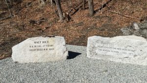
We cross a road to start on the short walk to the tunnel. Here it’s a shorter walk, and we feel as though we’re being watched. A car with Connecticut license plates sits on the other side of the tracks, it looks like a cop car. We keep to the left of the tracks and only cross over once to look at a memorial.

Our journey ends there when we see a sign that reads, “DANGER, ACTIVE RAIL LINE, NO TRESPASSING.” We decide that it’s a better idea to take pictures from afar, and not risk it. The active rail line, the strange car, and the waterfall nearby keep us firmly planted in one spot.

This side is more human than the other. The area seems more active with human activity, with the houses, the frequent visitors, and especially from the maintenance truck that drove up just as we were heading out. Despite the portals connecting to the same tunnel, the differences are startling.

On one end, it seems to be an aspect of life. The East Portal, alight with activity, with continued use and maintenance.

The tunnel itself, although grim, seems like the death of the area (remembering, also, how the fumes inside the tunnel will kill anything that is in the tunnel while a train goes by). Because the tunnel itself killed so many in production, this only reminds us of the ghost stories, the afterlife that the tunnel brings.

The West Portal, into the conclusion, appears as the regrowth. The moment where humans have gone and the beavers return, buildings fall apart and few come to see what has become of it.

Strangely, or maybe not, we find the West Portal far more comfortable. Perhaps it’s being closer to nature, or the excitement of the beavers. At the East Portal, we spend ten minutes there, tops, and leave practically right away. The adventure wears off quickly, and we pack up to travel to the place we know and love: the West.

Contract Narrative

North Adams exists as a hub of activity, and commonly is called a “drive-through town.” Even the trains are driving from one place to another, trying to get to somewhere else, never stopping for long.

Much of North Adams is historic, run down, falling apart or somehow being “reclaimed by nature” if you prefer to romanticise it in that way. Old Victorians, falling apart, or apartment buildings marked with signs that say it is no longer safe to enter. One can walk into any old house and see dandelions peeking through the floorboards.  Or walk through the various historic sites, of the Hoosac Tunnel, perhaps, and see pieces of the past, where nature exists within history.

Like the beavers who live alongside the West Portal, creating shapes, changing the landscape, and adding to it as parts break, we as humans do the same thing.

The history of the Hoosac Tunnel is rich with individual narratives, horrible deaths, and more, which enable the stories of the tunnel to be all the more interesting. With the wide range of stories, there enables a wide range of materials to show them, including TimelineJS, Storymap, of course visual aspects such as video, and the more straightforward nature writing.

The Vault will play into our writings as well. The archives we have access to, mostly documents which have been scanned and posted online, will aid us in our research. Physical artifacts will help us as well, and the aid of the local historical society will be of great use to us.

Our schedule is very loose, as we may change dates as time goes on, including adding more due dates as they come.  For now the schedule is as follows:

February 22 : Compiling a list of names of dead

February 22 – 25:  Figuring out what materials we need

February 26 – March 2 : Visiting the Library and the Vault. Seeing the artifacts

March 3 : Visiting the Historical Society (10am to 4pm)

March 4: Visit the East Portal, nature writing on site, some B-roll footage if possible.

We have also designated some responsibilities for the two of us.

Cassie: TimeLineJS, StoryMap, maintaining the blog/ writing pieces, research/ visiting the site. Positive affirmation guide / spotter of beavers.

Erica:  filming and editing videos, maintaining the blog/ writing pieces, research/ visiting the site. Driver / navigator extraordinaire.

The Hoosac Tunnel, although well known, has much that is no longer understood. In seeking the truths that the tunnel will tell, we may be able to see more than what even the builders themselves fully intended to show.

The Hoosac Tunnel

Archival documents were mostly found online through the form of photos and maps. The most promising vessel of information discovered from the North Adams Public Library happened to be Builders of the Hoosac Tunnel by Cliff Schexnayder. This particular text contains over 500 pages of history of the Hoosac Tunnel as well as over 123 pages of bibliography and endnotes (a true brick of information). With some help from a mutual friend (an expert in the Hoosac Tunnel, and currently working as a railway dispatcher near Boston), I was able to find some promising sources of photos, stories, and other information. Some websites need some further research to prove the validity of the information (for example I found some conflicting information from one site to the book – the same event, however dated during two different days), however they do seem promising as far as picture sources.

Overall the materials found and used enabled me to understand much more about the location itself than I knew already. Living in this area for 3 years, there are a lot of stories you hear just in day to day life, especially from asking locals or those who have lived here their whole life. Actually sitting down and being able to read about the history of this place, as well as seeing this place in the few photos taken as well creates a new life for this location. It is really different sort of understanding that there are a lot of ghost stories surrounding the area and then actually discovering that over 100 people died in the tunnel itself (not to mention the some 90 people that died elsewhere around the property).

The TimelineJS program really puts everything into perspective, seeing everything laid out in a numerical way. Watching the creation of the tunnel, essentially, as the timeline lays out the dates. I think it is really useful, especially for this project, because it was a very long process. The other program, StoryMap, would have been great as well, however due to the fact that we do not have pictures of the locations yet, it would make it difficult to create a map. Overall the Timeline seems to be a better resource for us for this location. There are a lot of events happening almost simultaneously, so it is nice to see it laid out in a clean, simplified way.

Once we have more information, videos, other photos, and more, I think it would be interesting to combine the information into the StoryMap as well as use the TimeLine. Because the tunnel is so long (over 4 miles) it would be interesting to layout all the information possible onto a map. For now, however, the timeline works well with what we currently have.


Book Citation:

Schexnayder, Cliff. (2015). Builders of the Hoosac Tunnel. Portsmouth, New Hampshire: Peter E. Randall Publisher.